
All About Stars
- STEAMworks OC
- Sep 20, 2020
- 4 min read


Clouds can be really fascinating. If you look up at the sky they can start to make shapes. They could be white as snow or as dark as a shadow. And depending on the weather they can look soft and fluffy or pretty scary. Clouds can even predict the weather! What makes clouds do all sorts of these wild things? Let’s dive into it.
Where do clouds come from?
In order to understand everything about clouds we first should figure out how they form in the first place! The recipe to make a cloud is simply dust and water. Water evaporates to form water vapor and that water vapor is found in the atmosphere where clouds form! The dust found in the atmosphere attracts the particles of water vapor and they condense to form a cloud. Water vapor keeps collecting around these dust particles until a cloud is formed! The best way to understand this is through an example. When you touch a puddle of water some of that water clings to your finger leaving it wet, even after you pull away from the puddle. That water left on your finger is exactly what happens when dust particles grab onto water vapor to form clouds! These “cloud droplets” are much smaller than raindrops and their size and lightness is why they float in the air! Wind up in the atmosphere pushes thousands of these “cloud droplets” and that is what makes clouds move!
Types of Clouds
In order to organize the clouds scientists have split them up into three groups: high, middle, and low clouds. The words “high”, “middle”, and “low” refer to the height of the cloud in the troposphere. The troposphere is the lowest section of the atmosphere and it contains the air we breathe everyday. The high clouds are known as cirrus clouds, the middle are called alto clouds, and the lowest clouds are called stratus clouds. These three types of clouds can be divided up into even more categories of clouds. Let’s learn a little about the three major types of clouds!
Cirrus Clouds
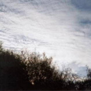
The first type of cloud we’re going to talk about are the highest groups of clouds called cirrus clouds! Cirrus clouds can be further broken down into three types of clouds called cirrus, cirrostratus, and cirrocumulus. Since cirrus clouds are so high up in the troposphere (above 18,000 feet in the air) temperatures in this area get extremely low. Therefore, cirrus clouds are mostly made up of ice. Normal cirrus clouds forecast a change in weather is about to come. They are known for their thin and wispy appearance.
The second type of cirrus clouds are cirrostratus clouds. These clouds are even thinner than cirrus clouds - so thin that you can see the Sun and Moon through them! Cirrostratus clouds are a sign that there will soon be rain or snow!
The third and final type of cirrus clouds are cirrocumulus clouds. These clouds look like small white balls that appear in rows. These clouds are mostly found in winter and forecast fair, but cold weather. In tropical regions however, this type of cloud can mean a hurricane is approaching.
Alto Clouds
The second type of clouds are known as alto clouds. These clouds can be found 6,500 to 18,000 feet in the air. Because of their height they are made up of ice crystals and water droplets, unlike cirrus clouds which are entirely made up of ice. There are only two subcategories of alto clouds.
The first type of alto clouds are called altostratus clouds. These clouds cover the entire sky and are grey-ish in appearance. A rain or snow storm is on its way!
The second type of alto clouds are known as altocumulus clouds. These clouds form in groups of grey balls and fill up the entire sky. If you see these clouds on a warm morning it means thunderstorms could appear in the afternoon.
Stratus Clouds
The lowest and third type of clouds are known as status clouds and they can be found up to 6,500 feet in the air. These clouds cover the entire sky and resemble fog that hasn’t reached the ground yet. There are three types of these clouds. Regular stratus clouds mean a light drizzle may occur.
The second type of stratus clouds are called stratocumulus clouds. These clouds are puffy and gray and sometimes form rows. Not much weather occurs with these types of clouds but they can become the next type of stratus clouds called nimbostratus clouds.
The third and final type of stratus clouds are called nimbostratus clouds. These clouds are dark gray and cause rain or snow. The rain or snow is usually light to moderate though.
Cumulus and Cumulonimbus Clouds
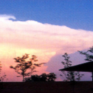
There is one more type of cloud that is extremely important in understanding the weather and it is by far the most famous type of cloud. When you think of a cloud you think of a white, fluffy, shape. This generic image of a cloud that everyone thinks of is known as a cumulus cloud! These clouds mean good weather is on its way! However things can go south quick!
If cumulus clouds grow too big they become extremely dark and gray. They can even look like mushrooms. These clouds are known as cumulonimbus clouds and they cause thunderstorms, snow, hail, and even tornadoes.
Conclusion
Now that you know all about the clouds you can predict weather! You can use this as a pretty cool trick for your parents and friends but it also can be pretty useful! Next time you go cloud watching watch out for anything big, dark, and scary. You’re an official cloud expert now.


Comments